The mountains · 4 min read山地 · 约 4 分钟
Charyn, Kaindy and Kolsai恰伦、凯因迪与科尔赛
One long day: a red-rock Valley of Castles, a lake of drowned spruce from the 1911 earthquake, and the pearls of the Tian Shan.漫长的一天:红岩城堡谷,1911 年地震淹出的云杉沉林湖,还有天山的明珠。
The September 29 group tour packs three of southeastern Kazakhstan's best-known landscapes into one very long day: a red-rock canyon in the dry steppe, a lake full of drowned trees, and an alpine lake in a spruce-forested gorge. It means a lot of driving. Charyn alone is about 200 km east of Almaty, and the lakes are farther still, up in the mountains near the Kyrgyz border. Expect to leave early and return late.
Charyn Canyon
The Charyn River runs down from the Tian Shan and has cut a canyon about 154 km long, in places 150 to 300 meters deep, through layers of sedimentary rock. It's often compared to a small Grand Canyon, and it's been a national park since 2004.
Most visitors come for one section, the Valley of Castles (Dolina Zamkov): a side canyon where erosion has sculpted the red and orange sandstone into towers, walls and battlements. A trail runs about 2 to 3 km down the valley floor between the formations to the river, where there's a small eco-park area with a café. The walk down is easy. The walk back up is gentle but in full sun, so carry water and a hat, and budget time for the return.
Scientists who studied Charyn's layers found an unbroken record of roughly five million years of climate history in the sediments. Nearby, the canyon also shelters a relict grove of Sogdian ash, trees whose ancestors grew here before the last ice ages.
Kaindy: the sunken forest
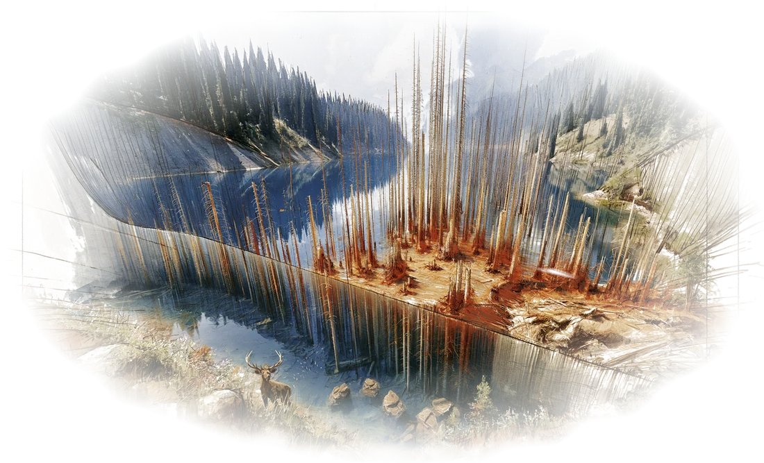
Lake Kaindy sits at about 2,000 meters in a narrow spruce-lined gorge. It's only about 400 meters long, but it's famous for one thing: the bleached trunks of Schrenk's spruce that stick straight up out of the turquoise water, like the masts of a sunken fleet.
The lake is young. In January 1911 a powerful earthquake (the Kemin or Kebin earthquake, the same one that damaged Verny, today's Almaty) set off a huge limestone landslide that dammed the gorge. Water backed up behind it and drowned the forest standing in the valley. The cold, clear water has preserved the trunks below the surface for more than a century. On a still day you can see the ghostly branches under water.
Getting there usually involves the last stretch on a rough track, often in a local 4x4 van or on foot, and sometimes on horseback, since regular tour buses can't manage it. From the parking area it's a short but steep walk down to the shore.
Kolsai: the pearls of the Tian Shan
The Kolsai lakes are a chain of three glacial-valley lakes stepping up a gorge in the Kungei Alatau range, often called the "pearls of the Northern Tian Shan." The name is literal: köl is lake and sai is gorge. They're protected within Kolsai Lakes National Park (which also includes Kaindy).
- Lower Kolsai, at about 1,800 meters, is the one you can drive to. It's the easiest to visit, with a lakeshore path, rowboats in season, and dark spruce forest rising on both sides.
- Middle Kolsai is a hike of several hours up the valley, or a horse ride.
- Upper Kolsai is higher still, near the pass to Kyrgyzstan's Issyk-Kul region, and is a serious trekking destination.
On a one-day tour from Almaty you'll almost certainly see just the lower lake, which is the classic view. Horses are often available at the lakeshore for a short ride up the trail toward the middle lake. Agree on the price and duration before you get on.
Saty
The gateway to both lakes is Saty, a small Kazakh village in the valley below, with guesthouses, cafés and the local drivers who run the 4x4 shuttles to Kaindy. It's the kind of place where the cows walk down the main road at dusk. Tour lunches are often served here.
Tips for the day
- Layers. Charyn can be hot and dry; the lakes, 1,000 meters higher and in the forest, are much cooler, especially in late September. Bring a warm layer and a rain jacket.
- Cash and QR. Park fees and small cafés are usually covered by the tour or payable by Kaspi QR (which Alipay can scan). A little cash helps for horses and snacks.
- Motion sickness. It's a long day of driving on some winding roads. Take something if you need it.
- Border zone. The lakes are near the Kyrgyz border. Carry your passport.
In one day the land goes from red desert canyon to drowned spruce forest to alpine lake.
9 月 29 日的拼团一日游,要把哈萨克斯坦东南部最有名的三处风景塞进漫长的一天:干旱草原上的红岩峡谷、一汪泡着枯树的湖,还有云杉峡谷里的高山湖泊。这意味着大量车程。光恰伦就在阿拉木图以东约 200 公里,两个湖还要更远,在靠近吉尔吉斯斯坦边境的山里。做好早出晚归的准备。
恰伦峡谷
恰伦河从天山奔流而下,在层层沉积岩中切出一道长约 154 公里的峡谷,有的地段深达 150 到 300 米。人们常拿它比作缩小版的美国大峡谷,2004 年起这里成了国家公园。
大多数游客只冲着其中一段来:城堡谷(Dolina Zamkov)。这是一条支谷,红色、橙色的砂岩被侵蚀成塔楼、城墙和垛口的模样。一条步道沿谷底在岩柱间穿行约 2 到 3 公里,一直通到河边,那里有个小小的生态园区和一家咖啡馆。下去很轻松;回来虽然坡缓,却一路暴晒,记得带水带帽子,给返程留足时间。
科学家研究恰伦的岩层时,在沉积物里发现了一段连续约五百万年的气候记录。峡谷附近还护着一片孑遗的粟特白蜡林,它们的祖先在末次冰期之前就已生长于此。
凯因迪湖:水下森林
凯因迪湖位于海拔约 2,000 米的一条窄峡谷里,两岸长满云杉。湖只有约 400 米长,却凭一样东西出了名:一根根被泡白的雪岭云杉树干笔直地戳出碧绿的湖面,像一支沉没舰队的桅杆。
这个湖很年轻。1911 年 1 月,一场强烈地震(克明地震,也叫凯宾地震,正是重创维尔内、也就是今天阿拉木图的那一场)引发了大规模的石灰岩山体滑坡,堵住了峡谷。水在坝后越积越高,淹没了谷底的整片森林。冰冷清澈的湖水让水下的树干保存了一百多年。无风的日子里,能看到湖面下影影绰绰的枝杈。
最后一段路通常是崎岖的土路,普通旅游大巴开不进去,一般要换乘当地的四驱面包车,或者步行,有时也骑马。从停车场下到湖边,路不长但很陡。
科尔赛湖:天山明珠
科尔赛湖是昆格伊阿拉套山一条峡谷里三个阶梯状排列的冰川谷湖泊,常被称为**“北天山的明珠”。名字就是字面意思:köl 是湖,sai 是峡谷。三湖都在科尔赛湖国家公园**的保护范围内(凯因迪湖也归它管)。
- 下科尔赛湖,海拔约 1,800 米,车能直接开到,最容易去。有沿湖步道,季节合适时可以划船,两岸是黑压压的云杉林。
- 中科尔赛湖,要沿山谷徒步几个小时,或者骑马上去。
- 上科尔赛湖,更高,接近通往吉尔吉斯斯坦伊塞克湖地区的山口,是正经的徒步目的地。
从阿拉木图出发的一日游,基本只会看到下湖,也就是最经典的那个画面。湖边常有马可骑,能沿步道往中湖方向走一小段。上马之前先把价钱和时长谈好。
萨特村
去两个湖都要经过萨特村,山谷里的一个哈萨克小村子,有民宿、小饭馆,还有跑凯因迪湖四驱接驳的本地司机。这是那种傍晚牛群会顺着主路慢悠悠走回家的地方。团餐通常就在这里吃。
当天小贴士
- 分层穿衣。 恰伦可能又热又干;两个湖高出一千米,又在林子里,凉得多,九月下旬尤其如此。带一件保暖外套和一件雨衣。
- 现金和扫码。 公园门票和小饭馆一般已含在团费里,或者可以扫 Kaspi 码付(支付宝能扫)。骑马、买零食最好备点现金。
- 晕车。 一整天都在车上,有些路段弯多。容易晕车的话提前吃药。
- 边境地带。 两个湖都靠近吉尔吉斯斯坦边境,护照随身带好。
一天之内,从红色荒漠峡谷,到淹没水中的云杉林,再到高山湖泊。
Where this shows up on the trip行程里对应的日子