South Island · 7 min read南岛 · 约 7 分钟
The West Coast: Arthur's Pass to the Buller西海岸:从亚瑟隘口到布勒峡谷
On the other side of the Southern Alps is a different country. The West Coast, in Māori Te Tai o Poutini, is a thin strip of land about 600 km long, squeezed between the mountains and the Tasman Sea, with only around 32,000 people living along it. It's wet, green, a little rough around the edges, and proud of it. People here call themselves Coasters. Our crossing takes two days: over Arthur's Pass to Hokitika, then north up the coast to Punakaiki and inland through the Buller Gorge toward Marlborough.
Rain on the right side of the mountains
The moist westerly winds off the Tasman hit the Southern Alps head-on and drop their water. Towns on the coast get several meters of rain a year, and the ranges above get much more. You feel the switch at the top of the pass. The Canterbury side is dry, brown and open; the West Coast side is dripping temperate rainforest: tall rimu and kahikatea, tree ferns, moss on every branch and, farther north, groves of nīkau, the world's southernmost palm. When the sun is out, it's one of the most beautiful coastlines on Earth, all long gray beaches, driftwood and huge sunsets over the sea.
It also has sandflies. Keep the repellent from Fiordland handy.
Over Arthur's Pass
From the Mackenzie Basin the route runs up through Canterbury's foothill towns and then climbs State Highway 73 into the mountains. It is the highest of the three main road passes over the Alps, at 920 m. It's named for the surveyor Arthur Dudley Dobson, who crossed it in 1864, though Māori had long used the route to carry pounamu east. Gold changed everything. When gold was found on the West Coast in 1864, a coach road was built over the pass within a couple of years and opened in 1866. The railway followed much later: the 8.5 km Otira rail tunnel under the pass opened in 1923. Arthur's Pass National Park, created in 1929, was the first national park in the South Island.
Stops along the way, from east to west:
- Castle Hill / Kura Tāwhiti. A basin of huge gray limestone boulders scattered over tussock hills, the eroded remains of a seafloor laid down some 30 million years ago, the same era as the Pancake Rocks. The Ngāi Tahu name means "treasure from a distant land." On a 2002 visit the Dalai Lama reportedly called it a spiritual center of the universe. It's a short, easy wander and a world-famous bouldering spot.
- Cave Stream. A 362 m cave that you walk through, upstream, in the stream itself: knee- to waist-deep cold water, a small waterfall to climb at the end, total darkness. You need a headlamp each, warm layers and shoes that can get wet, and never go in after rain. Even if you skip the cave, the loop walk above it is worth ten minutes.
- Lake Pearson / Moana Rua. A still, reedy lake beside the road, good for a pause and a reflection photo.
- Devils Punchbowl Falls. From Arthur's Pass village, an hour's return walk with plenty of stairs leads to a 131 m waterfall pouring off a cliff into the valley.
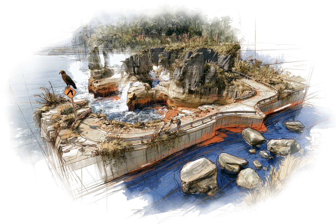
- The Otira Viaduct. West of the summit, the road plunges into the Ōtira Gorge, some of the steepest state highway in the country. For a century it was a narrow, crumbling zigzag. Since 1999 it has run along the 440 m Otira Viaduct, a concrete bridge that curves across the unstable valley side, with a shelter tunnel over the road where avalanches and rockfall come down. Stop at the lookout just above it for the classic view.
- Lake Brunner / Moana Kotuku. A detour off the main road on the West Coast side, a big quiet lake ringed by forest.
Hokitika and pounamu
Hokitika was a gold-rush boomtown. It was founded in 1864, and within a couple of years it was one of the busiest ports in the country, with ships wrecking regularly on its treacherous river bar. Today it's a small, pleasant town with a driftwood-strewn beach, sunsets over the Tasman and, above all, pounamu.
The South Island's Māori name, Te Waipounamu, means "the waters of greenstone," and this is where the greenstone comes from. Pounamu is New Zealand jade, mostly nephrite, found in West Coast rivers, especially the Arahura just north of town. For Māori it was the hardest and most precious material they knew, made into tools, weapons and taonga (treasures) such as the hei tiki pendant and the mere club, and handed down through generations. Routes over the Alps, including Arthur's Pass, were greenstone trails.
Since 1997, all pounamu in its natural state within Ngāi Tahu's territory, which covers most of the South Island, belongs by law to Ngāi Tahu. Hokitika's carving studios are the place to watch it being worked and to buy it. Look for pieces certified as New Zealand pounamu, since cheaper imported jade is common. Many New Zealanders hold that pounamu should be given, not bought for yourself, so a piece makes a good gift for someone else.
Just south of town, Lake Mahinapua is a calm, tannin-dark lake backed by forest and separated from the sea by a thin strip of dunes.
Punakaiki's pancake rocks
North from Hokitika, past Greymouth, the coast road runs between cliffs and surf to Paparoa National Park and the Pancake Rocks at Dolomite Point near Punakaiki. They're limestone, formed around 30 million years ago from the shells of sea creatures on the seafloor, when most of the old continent of Zealandia lay under water. Thin, soft layers of mudstone between the harder limestone erode faster, a process called stylobedding, leaving stacks that look like piles of pancakes. The sea has carved caverns and blowholes underneath. The paved loop walk takes about 20 minutes. The blowholes are at their best at high tide with a westerly swell, so check the tide times if you can.
While you're there, try a whitebait pattie, the West Coast's signature snack: tiny translucent fish bound in egg and fried, served on buttered white bread with a squeeze of lemon.
The Buller Gorge
At Westport the route turns inland and follows the Buller River up its gorge, a green-walled canyon of big rapids and forest. Near Westport, Cape Foulwind, named by Captain Cook in 1770 after a storm blew him off the coast, has a seal colony a short walk from the car park. Upstream, the Buller Gorge Swingbridge, at 110 m the longest swing bridge in New Zealand, hangs about 17 m above the river. On the far side are traces of the 1929 Murchison earthquake, a magnitude 7-plus quake that raised the ground by several meters and set off landslides all through the gorge. Past the small town of Murchison, the road leaves the West Coast behind and heads east to Blenheim and the vineyards of Marlborough.
Te Waipounamu, the waters of greenstone: the South Island is named for the jade in its West Coast rivers.
翻过南阿尔卑斯山,就是另一个国度。西海岸,毛利语叫 Te Tai o Poutini,是夹在群山和塔斯曼海之间的一条窄长地带,南北约 600 公里,沿线只住着三万两千人左右。这里潮湿、葱绿,带着几分粗粝,当地人也以此为傲,自称 Coasters(“海岸人”)。我们用两天穿过这里:先翻越亚瑟隘口到霍基蒂卡,再沿海岸北上普纳凯基,然后折向内陆,穿过布勒峡谷,开往马尔堡。
雨都下在山的这一边
从塔斯曼海吹来的湿润西风,迎面撞上南阿尔卑斯山,把水汽全卸在这里。海边的城镇一年降雨好几米,山里还要多得多。一过隘口顶,你就能感觉到这种切换:坎特伯雷那一侧干燥、枯黄、开阔;西海岸这一侧则是湿漉漉的温带雨林,高大的陆均松(rimu)和白松(kahikatea)、满眼的树蕨、每根枝条上都挂着苔藓;再往北,还有成片的尼考棕榈(nīkau),世界上分布最靠南的棕榈。太阳一出来,这就是地球上最美的海岸线之一:灰色的长滩、漂流木,还有海上铺天盖地的晚霞。
这里也有沙蝇。峡湾用剩的驱虫剂,放在手边。
翻越亚瑟隘口
从麦肯齐盆地出发,路线先穿过坎特伯雷山麓的几座小镇,再沿 73 号国道爬进山里。亚瑟隘口海拔 920 米,是翻越南阿尔卑斯山的三条主要公路里最高的一条。它得名于测量师亚瑟·达德利·多布森,他在 1864 年走过这里;不过早在那之前,毛利人就一直沿这条路把绿玉背往东边。真正改变一切的是黄金。1864 年西海岸发现金矿,短短两年内,一条马车路就修过了隘口,于 1866 年通车。铁路要晚得多:隘口下方 8.5 公里长的奥蒂拉铁路隧道,1923 年才开通。亚瑟隘口国家公园设立于 1929 年,是南岛第一座国家公园。
沿途由东往西,可以停这几处:
- 城堡山(Kura Tāwhiti)。 丛生草覆盖的山丘上,散落着一块块巨大的灰色石灰岩,那是约三千万年前一片海底被侵蚀后留下的残骸,和普纳凯基的千层饼岩是同一个年代。Ngāi Tahu 给它起的名字意为“远方来的珍宝”。据说达赖喇嘛 2002 年来访时,称这里是“宇宙的精神中心”。随便走走很轻松,这里也是世界闻名的抱石攀岩胜地。
- 洞穴溪(Cave Stream)。 一条 362 米长的溶洞,要逆着溪水从洞里穿过去:冰冷的溪水从膝盖没到腰,出口处还要爬一小段瀑布,洞里伸手不见五指。每人都得带头灯、保暖衣物和不怕湿的鞋,下过雨千万别进。就算不钻洞,洞顶上方的环线步道也值得走十分钟。
- 皮尔森湖(Moana Rua)。 路边一片静谧、长满芦苇的湖,适合停一停,拍一张倒影。
- 魔鬼潘趣碗瀑布(Devils Punchbowl Falls)。 从亚瑟隘口村出发,往返约一小时,台阶不少,尽头是一道从悬崖上倾泻进山谷的 131 米瀑布。
- 奥蒂拉高架桥。 过了垭口往西,公路一头扎进奥蒂拉峡谷,这是全国最陡的国道路段之一。一百年来,这里都是一段狭窄、不断塌方的之字形山路。1999 年起,公路改走 440 米长的奥蒂拉高架桥,一座贴着不稳定的山坡弯过去的混凝土桥,雪崩和落石多发的地段还罩着一段防护棚。桥上方有个观景台,经典角度就在那儿。
- 布伦纳湖(Moana Kotuku)。 在西海岸一侧离开主路绕一小段,一个被森林环抱的大湖,安安静静。
霍基蒂卡与绿玉
霍基蒂卡是一座淘金热里冒出来的城镇。它建于 1864 年,短短两三年就成了全国最繁忙的港口之一,船只却常在它凶险的河口沙洲上触礁失事。如今它是个宜人的小镇,海滩上堆满漂流木,塔斯曼海上落日壮观,而最重要的,是绿玉。
南岛的毛利名 Te Waipounamu,意思是“绿玉之水”,绿玉就出在这里。Pounamu 是新西兰玉,主要是软玉,产于西海岸的河流,尤其是小镇北边不远的阿拉胡拉河。对毛利人来说,这是他们所知最坚硬、最珍贵的材料,被制成工具、武器和 taonga(珍宝),比如 hei tiki 人形挂坠和 mere 短棍,一代代传下去。翻越南阿尔卑斯山的古道,包括亚瑟隘口,都是绿玉之路。
自 1997 年起,在 Ngāi Tahu 部落领地(覆盖南岛大部分地区)内,一切处于天然状态的绿玉依法归 Ngāi Tahu 所有。想看匠人雕琢绿玉、买一块绿玉,霍基蒂卡的雕刻工作室是最好的去处。认准有“新西兰绿玉”认证的作品,便宜的进口玉石很常见。许多新西兰人相信,绿玉应该是别人送的,不该自己买给自己,所以它很适合当作送人的礼物。
小镇往南不远是马希纳普阿湖,湖水被单宁染成深色,平静无波,背后是森林,和大海之间只隔着一道窄窄的沙丘。
普纳凯基的千层饼岩
从霍基蒂卡往北,过了格雷茅斯,海岸公路夹在悬崖和浪花之间,一路开到帕帕罗瓦国家公园,也就是普纳凯基附近多洛米特角的千层饼岩(Pancake Rocks)。这是石灰岩,约三千万年前由海洋生物的外壳在海底堆积而成,那时古老的西兰大陆大部分还沉在水下。坚硬的石灰岩层之间夹着薄而软的泥岩,泥岩风化得更快,这个过程叫缝合层理(stylobedding),最后留下一摞摞像煎饼一样的岩柱。海浪还在岩石底下掏出了洞穴和喷水孔。环形步道铺得很平整,走一圈约 20 分钟。喷水孔在涨潮、又赶上西向涌浪时最壮观,有条件的话先查一下潮汐时间。
来都来了,尝一个银鱼饼(whitebait pattie),西海岸的招牌小吃:一小把半透明的银鱼用鸡蛋裹起来煎成饼,夹在抹了黄油的白面包里,挤几滴柠檬汁。
布勒峡谷
到了韦斯特波特,路线折向内陆,沿着布勒河进入峡谷:两岸绿壁夹峙,急流翻滚,森林茂密。韦斯特波特附近的福尔温德角(Cape Foulwind),是库克船长 1770 年被一场风暴吹离海岸后起的名字,从停车场走一小段就能看到海豹栖息地。再往上游,布勒峡谷吊桥长 110 米,是新西兰最长的吊桥,悬在河面上方约 17 米。过了桥,还能看到 1929 年默奇森大地震留下的痕迹:那场 7 级以上的地震把地面抬高了好几米,整条峡谷都是山崩。过了小镇默奇森,公路就把西海岸抛在身后,往东开向布伦海姆和马尔堡的葡萄园。
Te Waipounamu,“绿玉之水”:南岛的名字,来自西海岸河流里的玉。
Where this shows up on the trip行程里对应的日子